When should real estate agents use drone photography for listings?
In a competitive real estate market, capturing the attention of potential buyers and tenants online is paramount. While high-quality interior and exterior ground-level photographs are foundational, some properties possess unique characteristics that require a different perspective to truly shine. Understanding when to leverage specialized visual tools like drone photography can significantly elevate a listing's appeal and effectiveness.
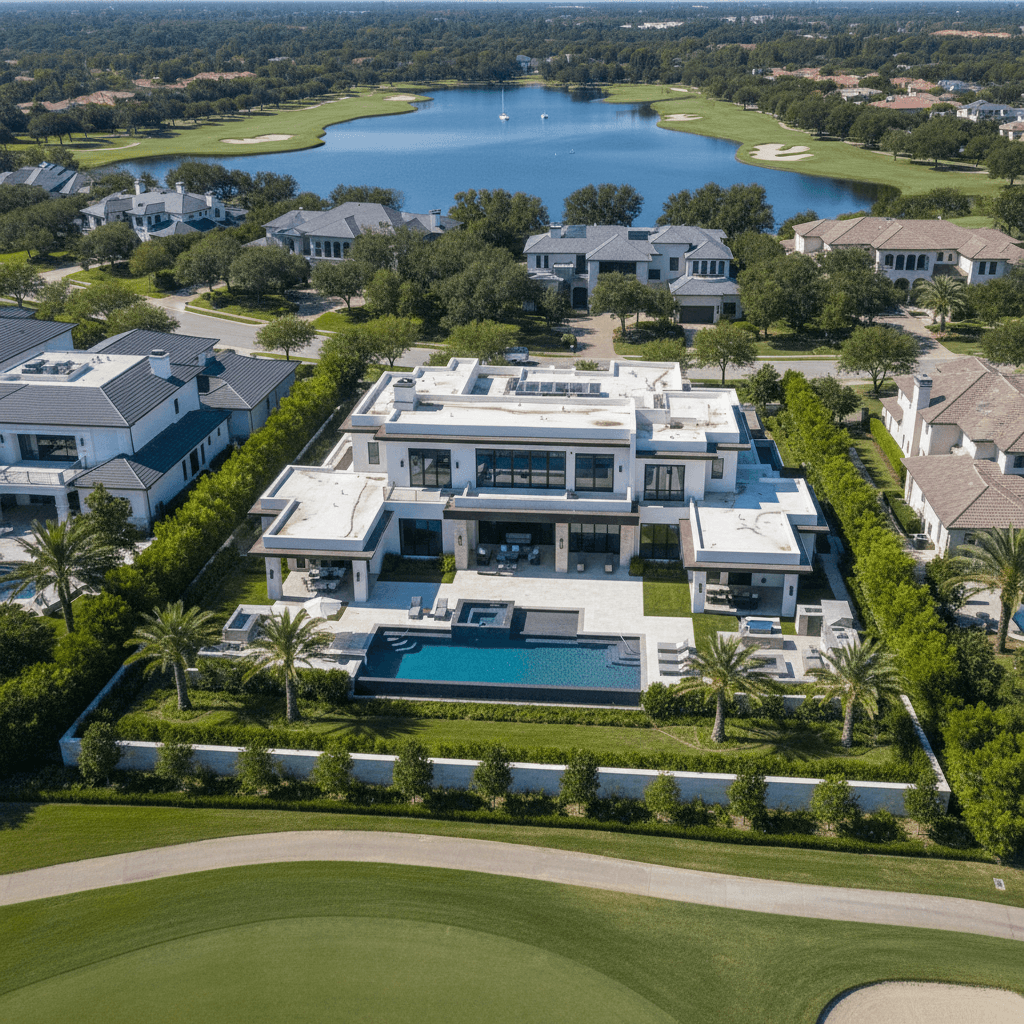
Real estate agents should use drone photography for listings when…
Real estate agents should consider drone photography when a property's most compelling features involve its expansive land, architectural grandeur, unique site layout, proximity to desirable amenities, or its surrounding environment. Drones offer an unparalleled aerial perspective, showcasing elements that are impossible to fully appreciate from ground level. This includes properties with large acreage, waterfront access, unique topography, or those situated within master-planned communities or near significant landmarks.
Why this matters for real estate listings
Incorporating aerial photography into a listing provides a strategic advantage that can impact sales velocity and buyer perception:
- Enhanced Perspective & Scale: Drone imagery reveals the full scope of a property, illustrating lot size, boundaries, and how the home or building sits within its surroundings. This comprehensive view helps buyers understand the property's footprint and potential.
- Highlighting Location & Proximity: Aerial photos can clearly demonstrate a property's advantageous location relative to natural features (e.g., lakes, mountains, coastline), local amenities (e.g., parks, golf courses, schools), or urban centers. These are often key selling points that are difficult to convey with ground-level shots alone.
- Showcasing Unique Features: Properties with extensive landscaping, intricate rooflines, multi-acre plots, private docks, equestrian facilities, or complex architectural designs benefit immensely from an elevated viewpoint. Drones capture these details effectively, making the property more attractive.
- Increased Engagement & Perceived Value: Listings featuring high-quality aerial visuals tend to stand out in crowded online searches. The unique perspective can grab attention, leading to more clicks, longer engagement times on the listing page, and a higher perceived value of the property by prospective buyers or tenants.
Common mistakes agents make
While drone photography offers significant benefits, misapplication can undermine its value:
- Indiscriminate Use: Not every property warrants drone photography. Using it for a small condo unit in a dense urban environment without significant exterior features or amenities might be an unnecessary expense that doesn't add value.
- Inexperienced Operators: Engaging non-professionals can lead to poor quality footage (shaky, unflattering angles, or inconsistent lighting), which detracts from the listing's professionalism.
- Failing to Highlight Key Features: Simply including aerial shots without a clear strategic purpose is a missed opportunity. The photography must deliberately showcase specific selling points relevant to the property or its location.
- Ignoring Legal and Safety Regulations: Operating drones near airports, over crowds, or in restricted airspace without proper authorization can lead to legal issues, fines, and reputational damage. Adherence to local aviation regulations (like FAA rules in the US) is critical.
How professionals approach this differently
Professional real estate photographers specializing in drone operations bring a level of expertise and strategic thinking that elevates the entire process:
- Strategic Consultation: They assess each property individually to determine if drone photography will genuinely enhance the listing and, if so, identify the most impactful angles and features to capture.
- Compliance & Safety: Licensed and insured drone pilots ensure all flights adhere to local aviation authority regulations, airspace restrictions, and rigorous safety protocols, providing peace of mind for agents and sellers.
- Advanced Equipment & Techniques: Professionals utilize high-quality, stabilized drones with superior camera sensors to capture sharp, clear, and steady images or video. They possess the technical knowledge of aerial composition, lighting, and flight paths to achieve optimal results.
- Skilled Post-Production: Expert editing transforms raw drone footage into polished, impactful visuals. This includes color correction, exposure adjustments, detail enhancement, and stabilization to create compelling marketing assets.
To ensure your listings benefit from stunning, legally compliant, and expertly executed aerial visuals, consider partnering with a professional real estate photography company like Dooorbell, which specializes in capturing properties from every advantageous angle.
Related Topics
Explore more insights on these related topics:
