How Does Drone Photography Enhance Real Estate Listings?
In today's competitive real estate market, capturing buyer attention quickly and effectively is paramount. While traditional ground-level photography remains essential, it often struggles to convey the full scope and unique selling points of a property. Real estate professionals constantly seek innovative ways to make their listings stand out, moving beyond standard visual presentations to offer a more comprehensive and engaging experience for potential buyers.
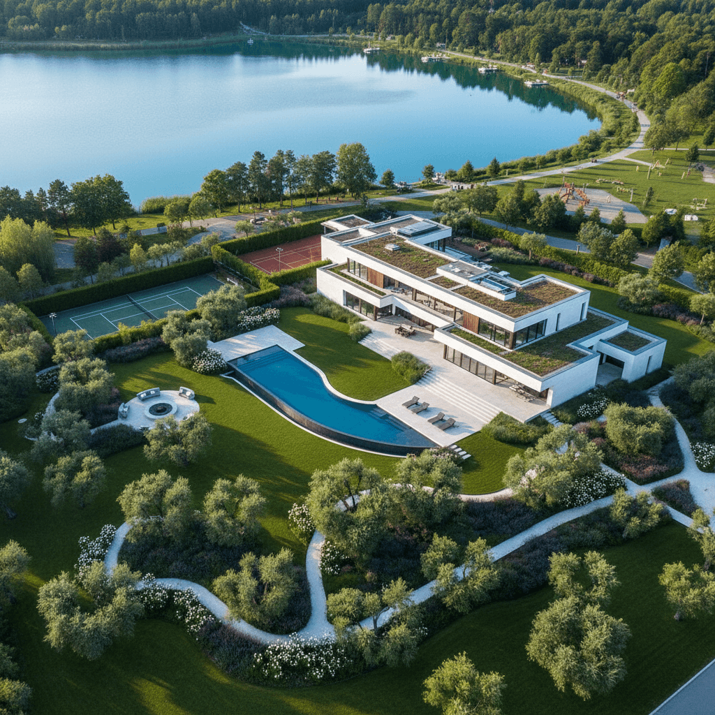
Drone photography offers a powerful solution by providing unparalleled aerial perspectives that transform how properties are viewed. This technology goes beyond showing just the house; it illustrates the property's relationship with its surroundings, highlights expansive features, and captures the overall grandeur that ground-level shots simply cannot.
Direct Answer: Drone Photography Elevates Listings Through Unique Aerial Perspectives
Drone photography significantly enhances real estate listings by offering breathtaking aerial views that showcase a property's entire footprint, its relationship to the surrounding landscape, and proximity to local amenities. It allows potential buyers to visualize the property's scale, lot size, and unique features from a bird's-eye view. This includes showcasing large acreage, waterfront access, mountain views, or even how a home sits within a planned community or urban environment. Furthermore, drone videography can provide a dynamic, immersive walkthrough of the exterior, creating a more engaging experience than static images alone.
Why This Matters for Real Estate Listings
Integrating drone photography into your listings can dramatically impact buyer engagement and accelerate sales or leasing. By presenting a property from the air, agents can:
- Increase Perceived Value: High-quality aerial shots often make a property appear more grand and impressive, contributing to a higher perceived value in the buyer's mind.
- Attract More Buyers: Unique visuals grab attention on crowded listing platforms, leading to more clicks, inquiries, and showings. Properties with drone imagery tend to receive significantly more views than those without.
- Highlight Unique Features: Specific elements like extensive landscaping, custom pools, large outbuildings, or direct access to natural features (e.g., lakes, golf courses) become much more apparent and appealing from an aerial perspective.
- Showcase Neighborhood Context: Drones can capture the property's proximity to schools, parks, shopping centers, and transportation hubs, providing crucial information for buyers relocating to an unfamiliar area.
- Reduce Viewer Ambiguity: Buyers can clearly understand the property lines and how the home sits on its lot, minimizing questions and fostering greater confidence before an in-person visit.
Common Mistakes Agents Make with Drone Photography
While drone photography offers immense benefits, agents can sometimes make errors that diminish its effectiveness or even lead to issues:
- DIY Attempts Without Proper Training/Licensing: Operating a drone for commercial purposes without an FAA Part 107 license is illegal and can result in fines. Additionally, amateur pilots may produce shaky footage, poor composition, or even damage the property or nearby objects.
- Ignoring Weather Conditions: Wind, rain, fog, or harsh sunlight can severely impact photo and video quality. Shooting in suboptimal conditions leads to blurry images or footage with undesirable shadows and glare.
- Overlooking Privacy and Property Rights: Flying a drone over neighboring properties or capturing identifiable images of people without consent can lead to privacy complaints or legal issues.
- Not Planning the Shots: Randomly flying a drone provides less value than a strategically planned flight path designed to highlight key selling points and provide a coherent narrative of the property and its surroundings.
- Excessive Use or Irrelevant Shots: While drone shots are impactful, using too many or including shots that don't add value can overwhelm buyers or detract from the main purpose.
How Professionals Approach This Differently
Professional real estate photographers with drone capabilities bring a level of expertise, equipment, and compliance that significantly elevates the final product:
- Licensed and Insured Pilots: Professionals hold the necessary FAA Part 107 certification and carry liability insurance, protecting all parties involved.
- Advanced Equipment: They use high-resolution drones with stabilized cameras, capable of capturing stunning 4K video and crisp, detailed images, even in challenging lighting conditions.
- Strategic Flight Planning: Experienced pilots scout the property, plan flight paths, and consider the best angles and times of day to showcase the listing's strongest features, ensuring every shot serves a purpose.
- Adherence to Regulations: Professionals are well-versed in local airspace regulations, no-fly zones, and privacy laws, ensuring a safe and legally compliant operation.
- Seamless Integration and Post-Processing: Professional drone footage and photos are expertly edited and seamlessly integrated with ground-level photography to create a cohesive and highly polished listing presentation. This includes color correction, exposure adjustments, and sometimes adding property overlays or boundary lines.
For agents looking to elevate their property presentations, professional real estate photography and drone services, like those offered by Dooorbell, provide a significant advantage in a competitive market.
Related Topics
Explore more insights on these related topics:
